Article and photographs by Oscar Frey
From Discourse 6
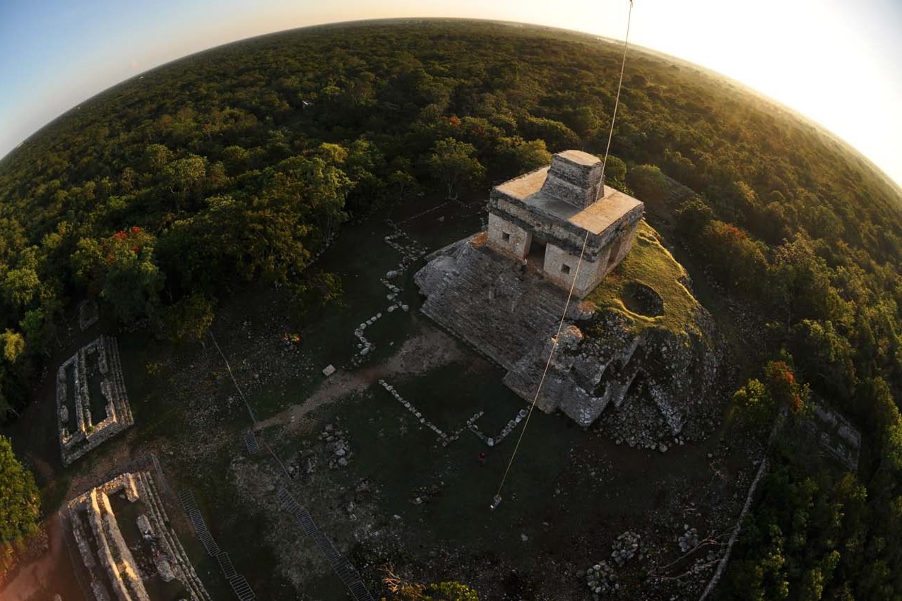
Sunrise at the Pyramid of the Seven Dolls, Yucatán Peninsula, Mexico. Fall equinox, September 22, 2009.
Kite aerial photography (KAP) has allowed me to widen my perception of the earth and has provided me a new approach to document natural resources and phenomena in a nonintrusive manner.
In November 2006, as I was attending a conference to present my results on KAP applications to studying humpback and gray whales, I was introduced to a group of scientists that work at the Marine Resources Research Center in Merida, Yucatán. This group described to me the richness of the natural resources found in the Yucatán Peninsula and pointed out locations with potential conditions for using kite aerial photography as a surveying technique.
From that moment, I started testing KAP in the Yucatán Peninsula. I explored the area in search of sites and species of interest to be photographed from above, especially within natural protected areas and national parks where KAP could provide a different perspective of the natural habitat, its geographical context, and the effect of human activities over it.
After surveying the area over the years following, I found that the Yucatán Peninsula offers great conditions for KAP in a wider extent. Its geographical features – such as having a flat topography and a wide continental shelf, and being surrounded by the ocean waters of the Gulf of Mexico and the Caribbean — provide unique oceanographical conditions and wind patterns that can be used for KAPing purposes. In addition, the Yucatán Peninsula has a great number of national parks and natural protected areas that host a very interesting blend of subjects to photograph from a kite. Three of them have really drawn my attention: the pre-Columbian Mayan ruins and archeological sites, the colorful landscapes in the vast areas of coastal lagoons and islands surrounding the peninsula, and the annual arrival of the largest fish on earth, the whale shark (Rhincodon typus).
During the summer of 2009, I went back to the Yucatán Peninsula with two purposes: to document the whale sharks, and to photograph the Mayan pre-Columbian city of Dzibilchaltun and the archeo- astronomical phenomena that occur at this site on the fall equinox of September 22nd.
DOCUMENTING THE WHALE SHARK
There is a whale shark population that gathers in large numbers to feed during summer months in the offshore waters of the Yum Balam Marine Reserve. This reserve is located on the eastern side of the Yucatán peninsula and it includes terrestrial and marine environments surrounding Holbox Island, Contoy Island, and Isla Mujeres, Quintana Roo, Mexico. Here, from May through September, the whale sharks gather to feed on massive plankton blooms, which occur over the shallow continental shelf as a result of the upwelling currents and the mixing of the Caribbean waters and the waters of the Gulf of Mexico.
In this area, fishermen have developed eco- tourist activities to use the whale sharks as a resource. They take tourists to swim with these amazing and inoffensive sharks. This does not mean that sharks are safe from the negative impact of human activities around them. So it is important to collect data that can enhance management strategies to protect the sharks’ environment and population. Kite aerial photography has the potential to provide valuable information and documentation for that purpose.
In July and August, I explored the Yum Balam Marine Reserve to test KAP and document the whale sharks, the coastal lagoons, and the islands. The purpose was to experience wind conditions at the coast and in the whale shark observation area offshore. I tested different kites, rigs, and cameras in order to determine the potential applications of KAP in this vast area.
The documentation of the whale shark at the Yum Balam Reserve became a very interesting and completely different challenge than documenting other pelagic species like the humpback or gray whales. The main difference is that whale sharks do not need to come to the surface to breath. They come to the surface to feed on shoals of zooplankton, and when that happens, it is very easy to observe them and track them. So it is the perfect moment for documentation to take place.
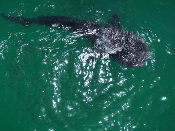
A 24 foot whale shark feeding over the shelf waters of Holbox Island. A school of herring is riding along, just visible in the lower left beneath the water’s surface.
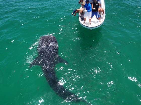
A whale shark posing for the cameras. This particular shark showed a curious behavior, as if he seemed to be attracted by the red color of the kite’s reflection (not shown) on the ocean surface.
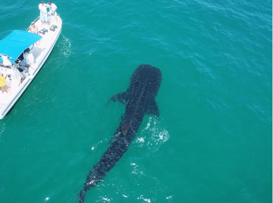
A 34 foot whale shark found feeding on the surface.
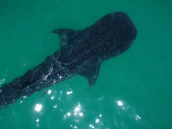
Drop shot over a whale shark. There are three ridges on the shark’s back, of which the center ridge is most visible in this photograph.
I used three different rigs with three different cameras:
- A light weight rig customized for the Olympus Tough 8000
- A medium weight rig built for the Coolpix 5000 with a 7.7mm fisheye lens
- A heavy duty rig built by Brooks Leffler for the Nikon D50 and customized to fit also the Nikon D90, both used with a 10.5mm fisheye lens or a 35mm lens
I used different Rokkaku and Flow Form kites during this expedition:
- A 9 foot long Rokkaku designed by Reza Ragheb, a 7 foot long Rokkaku designed and built by Mike Jones, and a 6 foot long Rokkaku designed and built by José Sainz
- A Sutton Flow Form 16 and a Sutton Flow Form 30 modified as a Christian Becot design with a window placed on the front portion of each of the side keels
The rig, the camera, the kite, and the line to be used were chosen depending on the wind conditions during each field trip and the application purposes.
I verified that the main difficulty in photographing the whale sharks with KAP is finding the appropriate wind conditions at the same time and place where you found the sharks on the surface. Most of the times, either it rained and the plankton would go deeper (and so would the sharks), or on clear days, by the time the wind picked up in the afternoon, the sharks would be already submersed.
To raise the camera over the whale sharks with the use of a kite was a real challenge. Basically, we needed several variables to interact simultaneously: the presence of whale sharks on the surface of the ocean, sunny or fair weather, enough wind speed to lift the camera, the right kind of kite and line, and — very important — a knowledgeable captain to maneuver the boat while the experiment was taking place.
The first challenge was to adapt to the variable wind conditions found in the area. The wind close to the coast was always much stronger than the wind conditions found offshore, so using different cameras and kites was the key to successful results. I never knew what wind conditions we would find offshore, even if the winds on shore or close to shore were good enough to lift almost any camera you would like.
I used a methodology developed in previous years for KAPing gray and humpback whales in a nonintrusive manner. The goal is to lift the camera from a 27 foot fiberglass boat without using the drag of the boat as a lifting force, just using the wind, and to maneuver the boat to stay upwind from the whale sharks in order to project the kite and camera over them and document them from above.
The results were very satisfying and surprising, even though I never had enough lifting power from the wind to lift the bigger rig with the Nikon SLR. The light and medium weight rigs performed very well at low altitudes with the Olympus and Coolpix cameras. Something really interesting was that the whale shark would be attracted by the shadow of the kite and the colorful reflection over the ocean surface when we used the red Rokkaku. This behavior made the documentation easier.
In conclusion, kite aerial photography has proved to be a nonintrusive technique useful in documenting the behaviors of the whale shark on the ocean surface. It has the potential to provide valuable information about this species and its relationship with humans for scientific and social studies, as it has done with other protected species in Mexico such as humpback and gray whales. It is important to continue testing KAP to document whale sharks at the Yum Balam Reserve in the future, with the purpose of providing information that could enhance its protection and management strategies.
DOCUMENTATION AT THE ANCIENT CITY OF DZIBILCHALTUN
I began testing KAP over the ancient city of Dzibilchaltun, a pre-Columbian Mayan city that dates from 400 BCE and was abandoned in 1600 CE. This archeological site is located 10 miles north of the city of Merida and 15 miles south from the coastline of Puerto Progreso. Its proximity to the ocean provides good wind conditions for KAPing most of the year. So it became my favorite site to practice KAP and develop applications for archeological purposes.
Every visit to this special site has been very different and the photographs speak for themselves. Panoramic views of this ancient city show the beautiful lushness of the natural environment surrounding the Mayan ruins, and the geometrical arrangement and spatial distribution of the pyramids in harmony with the environment.
A perfect orientation of the structures is very evident from the aerial perspective. The center of the city is the cenote of Xlaká, which was the main source of fresh water for Dzibilchaltun. The cenote is an oval- shaped pond with pristine emerald waters and blooming lilies floating on the surface. The pyramids and other structures distribute towards east, north, and south in a radial symmetrical pattern around this pond. Clearly, this was the center of the ancient city. The main square is located in the quadrant northeast from the pond. It is limited by four structures and has a chapel in the middle built during the Spanish conquest.
The most important building in the city is a particular pyramid at the far east of Dzibilchaltun. It is called the Pyramid of the Seven Dolls or the Observatory. It is located at the end of the Sac-be (ancient sacred white roads), which connect the main square of the city with this pyramid. The Observatory is a solar calendar which marks specific dates around the year through different projections of its shadow. On specific days of the year, the rays of the sun pass through the pyramid at sunrise and project over different structures in perfect alignment to indicate seasonal changes, such as the beginning of the spring and fall at their respective equinoxes.
I have been documenting this pyramid with KAP since November 2006, mostly in the afternoon when the winds from the shore pick up. The photographs show the relationship of this pyramid with the sun dial along the Sac-be, the beautiful untouched jungle surrounding the pyramid, and its harmony and perfect orientation. The photographs were used by archeologists to determine the state of the pyramid and its restoration to anticipate future damage from weathering. But I wanted to test a different application – I wanted to document the archeo-astronomical phenomenon at the spring and fall equinoxes.
I visited the site repeatedly, and I could not find any wind at sunrise on those dates in past years. So in order to solve that problem, I decided to test the use of a helium balloon to lift the rig. On September 22, 2009 we inflated a balloon with 6 cubic meters of helium and lifted my rig at sunrise, bearing a Nikon D90, to document the Pyramid of the Seven Dolls, the projection of its shadow, and the rays of sunlight passing through it.
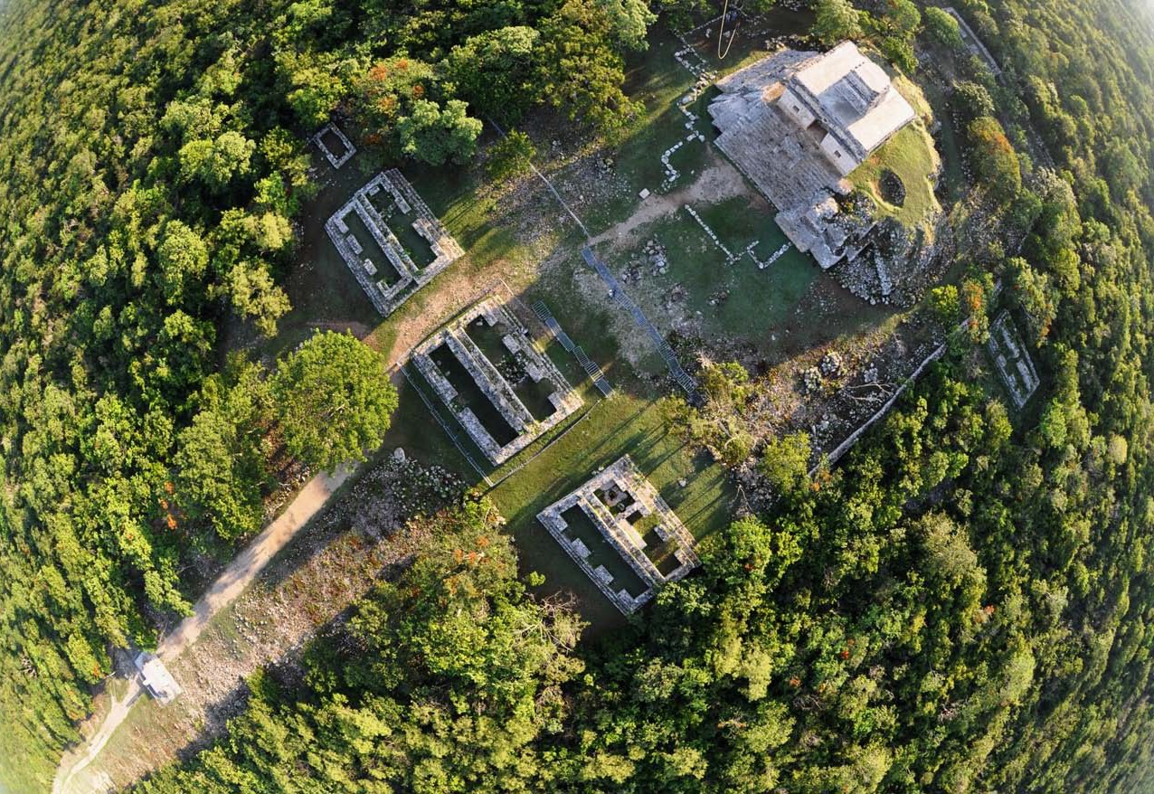
September 22, 2009, 7:31 am. Note the projection of the pyramid’s shadow over the structure in front of it. The solar ray passes through the pyramid and projects a beam (see arrow) that aligns with the middle window of the structure.
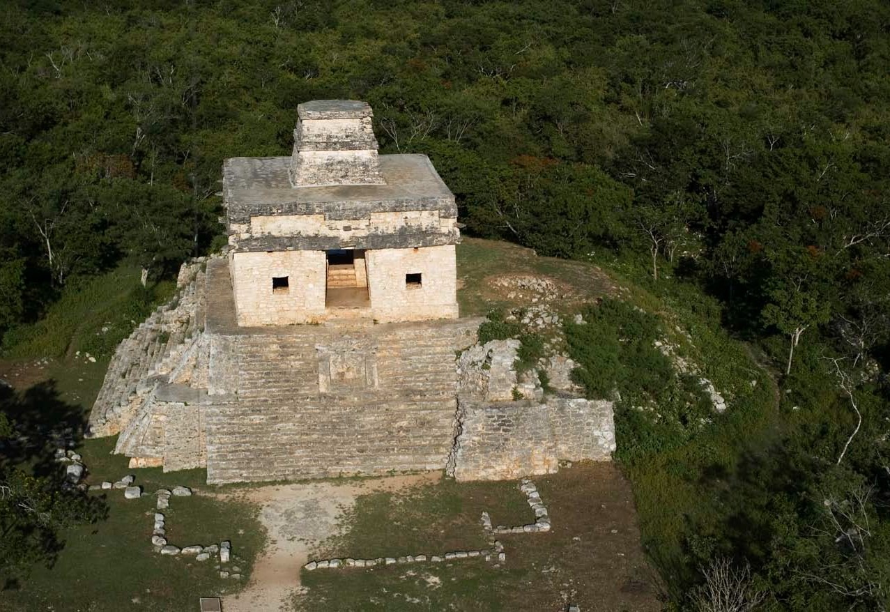
Another view of the Pyramid of the Seven Dolls at Dzibilchaltun, Yucatán, México, photographed with a Nikon D50 and a 35mm lens.
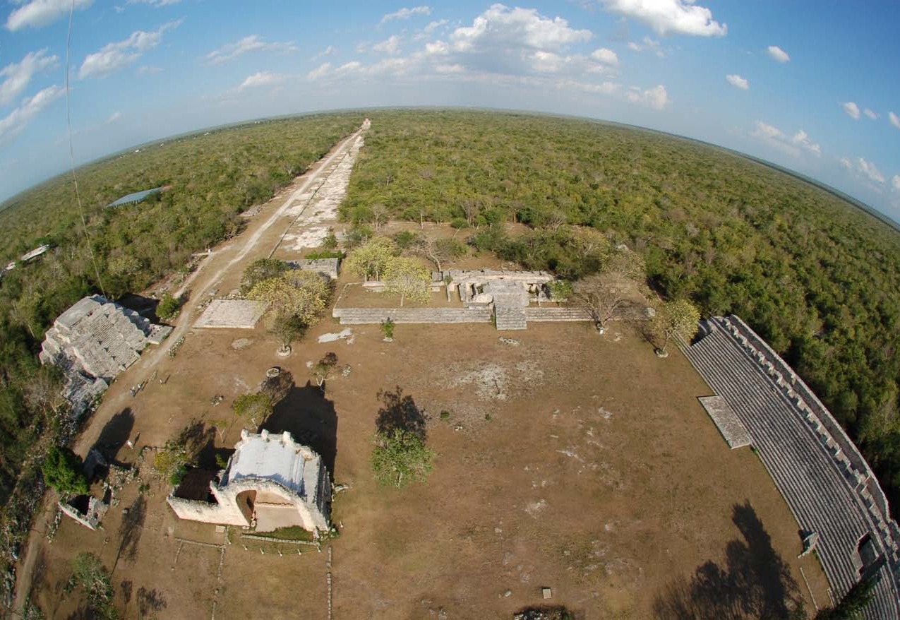
The pre-Columbian Mayan city of Dzibilchaltun, panoramic view towards the east from the main square. Note the chapel built in the center by the Spanish colony.
The results were more than satisfactory. Its aesthetic and scientific value came to light and, as I said before, the photographs speak for themselves. The photographs show that the projection of light that passes through the pyramid during sunrise at the equinox is perfectly aligned with the structure in front of it. It lasts exactly 60 minutes, proving that the Mayans not only had the concept of the solar system, they also had the concept of the hour as a fraction of the rotation of the earth.
CONCLUSIONS
The documentation of the ancient city of Dzibilchaltun and the documentation of the whale shark are two contrasting examples of the richness of the Yucatán Peninsula and its favorable conditions for kite aerial photography. I hope to inspire other KAPers around the globe to survey this area and discover the beauty of its national parks and natural protected areas and the warmth of its people.
Future applications of KAP in the Yucatán Peninsula are very diverse. They include the possibility of taking stereo photography of the Mayan ruins to update cartography records, documenting the breeding area of flamingos at Rio Lagartos and Celestun, documenting the erosion processes and sediment transport along the shoreline that surrounds the peninsula for protection management, and monitoring the aggregation of whale sharks to enhance conservation strategies.
Editor’s Note: An unprecedented – but very worthy – second grant was award by the Drachen Foundation Board of Directors to the National Institute of Anthropology and History/National Park of Dzibilchaltun for KAP of the site by author Oscar Frey.
ACKNOWLEDGEMENTS
I am very grateful to the National Institute of Anthropology and History. Special thanks to Diana Trejo, Director of the National Park of Dzibilchaltun, Yucatán, México and to the archeologist Rubén Maldonado for providing permits and authorizations to practice KAP repeatedly since November 2006, and for closing the park for such purposes.
A very special acknowledgement to the National Commission of Natural Protected Areas and the Director of the Yum Balam Reserve, Quintana Roo, Mexico for providing the authorization for KAP activities to take place at the whale shark observation area and Holbox Island during summer 2009. Special thanks to Francisco Remolina and Rafael de la Parra for their assistance and for believing in KAP as a valuable tool to document the whale shark in Mexico.
A special acknowledgement to Dr. Jorge Euán, director of the Laboratory of Remote Sensing and Geographical Information Systems at the Marine Resources Research Center in Mérida, Yucatán, for his interest and support for the application of KAP on different lines of research in the Yucatán Peninsula since November 2006. Thanks to Andrés Maldonado for his friendship and assistance during long and repeated field trips to Dzibilchaltun and for assisting me in the laboratory of image processing.
Thanks to Juan Ávila for his help with the boat operations and logistics, for his patience during long hours, and for the humorous spicy Caribbean ceviche moments.
Thanks to Alejandra del Castillo and Luca Sambuca for their friendship, support, sincerity, and the perfume of their Mediterranean cuisine.
A very special acknowledgement to Keith May, Nancy Ambé, and Gustavo Grageda for their friendship, dedication, patience, and support in the development of all KAPing activities at Holbox Island in July and August 2009.
My most gratitude to The Drachen Foundation for opening their hearts to me and introducing me to KAP. I am especially grateful to Alison Fujino and Scott Skinner for believing in me, for their assistance, prudent advice, and personal dedication in helping me develop the KAP Whales Project in Mexico since August 2003.
Thanks also to José Sainz for his advice on maneuvering kites, building the whale Rokkaku, and sharing tequila moments.
A very personal acknowledgement to Brooks Leffler and Peter Bults for their dedication in designing and building rigs customized for my SLR cameras and needs.
And not least important, I want to thank Mike Jones for designing and building the Rokkaku kites that I have been using in the Yucatán Peninsula under extreme conditions the last three years.
