
Article and photos by Oscar Frey
From Discourse 9
ARCHEOLOGICAL AND METHODOLOGICAL APPLICATIONS OF KAP TO STEREOSCOPIC PHOTOGRAPHY AND THE INFLUENCE OF OCEAN PROCESSES AND ENVIRONMENTAL CONDITION ON LOCAL WIND PATTERNS ON THE YUCATÁN PENINSULA, JULY 2010
In July 2010, Drachen Foundation and Deep Blue Conservancy supported Oscar Frey and his team to achieve new goals and results in the ongoing development of Kite Aerial Photography (KAP) applications to survey the archeological and natural resources of the Yucatán Peninsula.
Since 2006, we have done KAP surveys and workshops in the Yucatán Peninsula. We have achieved liaisons with different scientists and research institutions that are now providing new opportunities for the application of KAP in Mexico.
One of these new applications is to use KAP to obtain stereoscopic images. We tested this application over pre-Colombian Mayan ruins with the ultimate purpose to create a digital, three-dimensional reconstruction of the actual appearance of the pyramids.
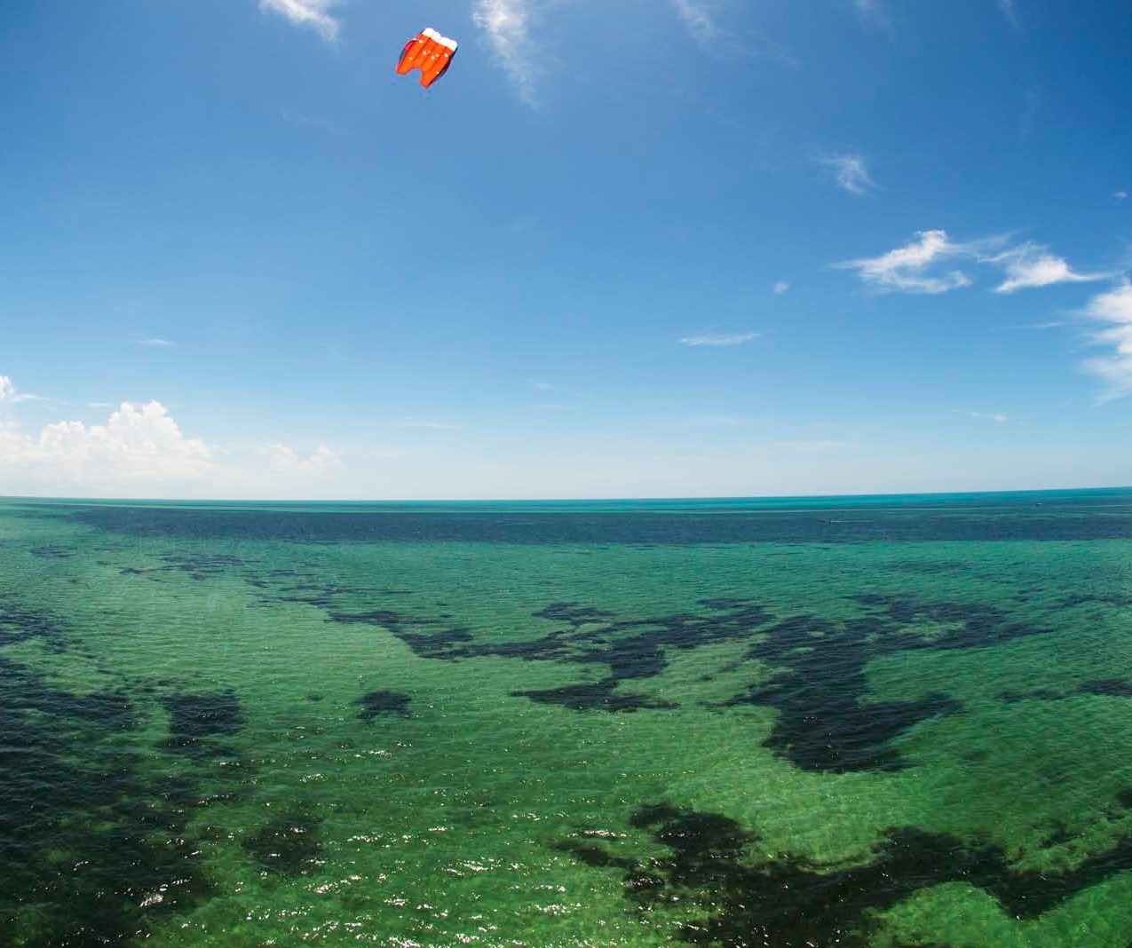
We also continued to experiment with KAP at Holbox Island and its surrounding waters in order to observe the ocean processes that influence local wind patterns and to continue developing new applications of KAP in Mexico.
OBJECTIVES OF THE EXPEDITION
- Survey the ancient city of Dzibilchaltun and test the application of KAP techniques to achieve stereo-photography results with the use of only one camera.
- Obtain pairs of photographs with a high percentage of overlap in order to appreciate the elevation or third dimension of the pyramids at Dzibilchaltun with the aid of a pair of stereoscopic lenses.
- Develop a digital, three-dimensional model of the Observatory or Pyramid of the Seven Dolls using the TNTmips and ArcGis software. This software allows us to process the topographic and geographical data obtained in the survey to build an elevation model of the pyramid. It also geo-references the aerial photographs obtained from the kite and lays them over the digital elevation model, providing the true appearance of a three-dimensional representation of the pyramid.
- Evaluate the environmental conditions and equipment needed to do KAP in the surroundings of Holbox Island and in the whale shark (Rincodon typus) observation area of Yum-Balam Reserve in Quintana Roo, Mexico.
- Evaluate the influence of the ocean processes and environmental conditions on the local wind patterns and its application to KAP activities.
AREA OF STUDY
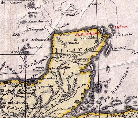
The KAP activities of this expedition were developed in two different parts of the Yucatán Peninsula: The first area of study was the ancient city of Dzibilchaltun (occupied from 400 BC to 1600 AD), located 7 miles north of the city of Mérida in the state of Yucatán. The second area of study was Holbox Island, located in the state of Quintana Roo on the farthest eastern side of the peninsula.
MÉRIDA, YUCATÁN, MÉXICO JULY 15 – 22ND 2010
The activities undertaken during this week were focused on the s tereoscopic photography applications of KAP. The activities included four surveys at the archeological site of Dzbilchaltun and the analysis of the data in the laboratory to test the possibility of achieving stereoscopic photography with KAP by using only one camera.
The main goal was to use KAP to document the terrace of the Seven Dolls where the Observatory or Pyramid of the Seven Dolls was built. We would obtain pairs of images with plenty of overlap in order to appreciate the elevation or depth of the pyramids, first with the use of stereoscopic lenses and later by creating a digital, three-dimensional model of the Pyramid of the Seven Dolls, illustrated below.
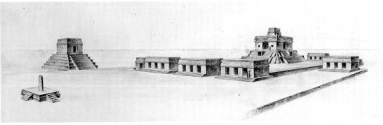
An illustration of the Pyramid of the Seven Dolls.
METHODOLOGY
Pairs of images can be obtained by shooting 8 frames per second with only one camera. When using KAP, the slight movement of the kite allows the camera to take the photographs from a slightly different position, having a great overlap between images. The images with the same exposure and where the whole structure appears were the ones ultimately selected.
To observe the depth or elevation on photographs using a stereoscope, we follow this methodology: First select a pair of images and place them under the lenses. View through the lenses, and with your right eye select on the image at right a landmark to use as reference. Point to it with your right fingertip. Locate the same landmark on the picture at left with your left eye, and point it with your left fingertip. Now with both eyes open, move one of the pictures to overlap the marked landmark on both images and adjust it until the depth or third dimension is appreciated. Or as described by Compton: “Select a distinctive feature lying near the center of the overlap area in a pair of photographs. Place the stereoscope over the photographs so that the two images lie under the centers of the two lenses or mirrors. By looking into the stereoscope, the viewer should be able to see a three- dimensional image.”
In order to create a digital, three- dimensional model of the Pyramid of the Seven Dolls, we made a topographical and geographical reference survey of the pyramid. This provided the data to create a digital elevation model with ArcGis software. Later, we laid aerial photographs over the model with the TNTmips software to reproduce the pyramid in a three- dimensional, digital format.
The photographs needed to create this digital model must have an equidistant scale on both sides of the frame, or in other words, no deformation. To obtain these types of images, the photographs need to be taken with a 35mm lens. This specification creates the need to elevate the camera at a higher altitude than when using a fish eye lens and therefore involves a greater degree of difficulty.
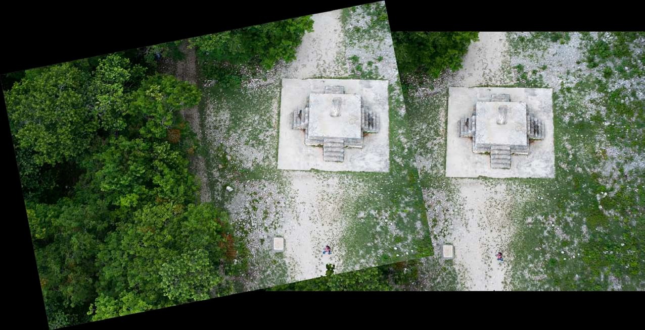
Pairs of photographs from KAP surveys at Mexico’s ancient city of Dzibilchaltun. The elevation or third dimension is appreciated through stereoscopic lenses.
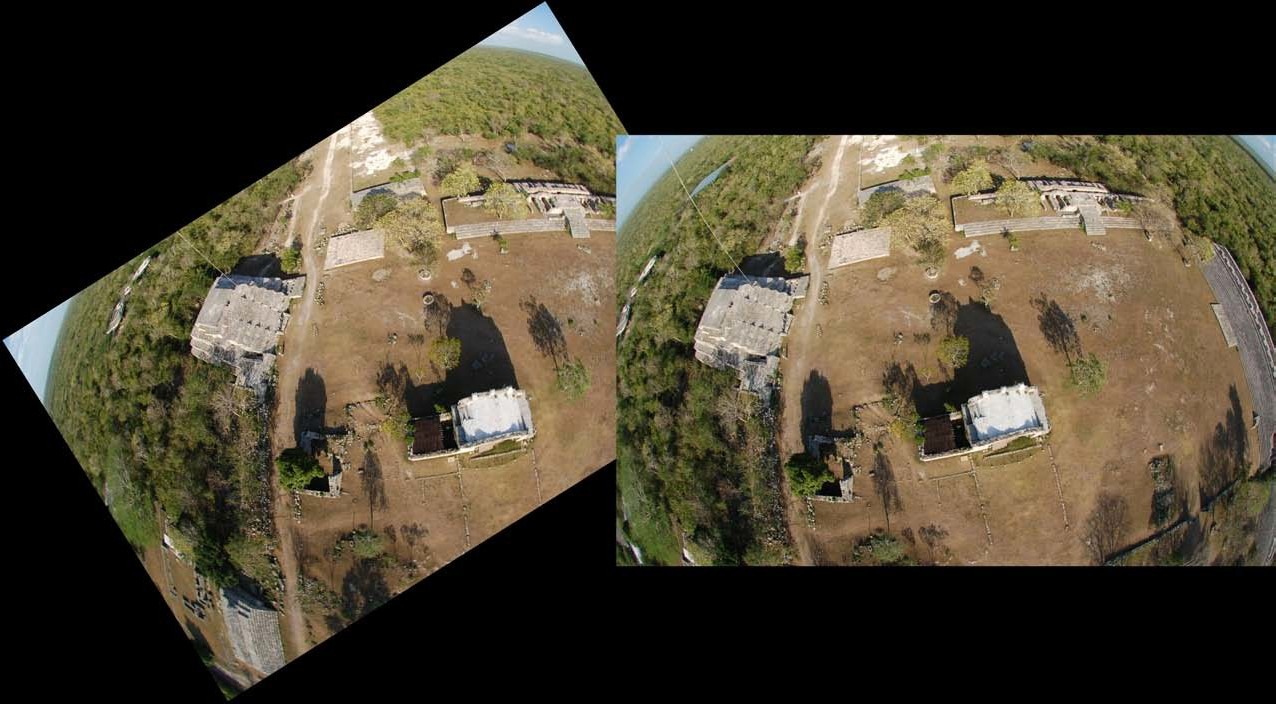
Pairs of photographs from KAP surveys at Mexico’s ancient city of Dzibilchaltun. The elevation or third dimension is appreciated through stereoscopic lenses.
RESULTS
The weather conditions during this expedition did not allow us to fly the kite and rig above the Pyramid of the Seven Dolls and get aerial photos of this structure with the 35mm lens. The scattered rainstorms and thunderstorms in the vicinity and at the archeological site reduced the windows of opportunity to make the complete flights possible. Nevertheless, we took aerial photos of the Sun Dial and we made the topographical survey of the Pyramid of the Seven Dolls to obtain the data required to create a digital elevation model of the pyramid. Later we processed this information with ArcGis software and obtained the following preliminary model:
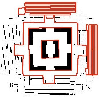
Digital elevation model of the Pyramid of the Seven Dolls.
We plan to go back to this archeological site during the early spring of 2011 in order to take aerial photos of the terrace of the Seven Dolls with the 35mm lens and to be able to finish the digital, three-dimensional model of the Observatory or Pyramid of the Seven Dolls at Dzibilchaltun.
To observe the third dimension with the use of a stereoscope or stereoscopic lenses, we selected pairs of photographs from the different KAP surveys done at this site. One pair was obtained from this expedition and the rest from previous years. After several experiments with different pairs of images, we noticed that the elevation or third dimension is appreciated through the stereoscopic lenses regardless of the lens used to obtain the images. (See page 29 for examples of photograph pairs.)
This proves that KAP can be used as a remote sensing surveillance technique to create high resolution 3D images in analog format and provides the evidence of its potential use in creating digital models of elevation.
HOLBOX, QUINTANA ROO, MÉXICO JULY 23RD – 29TH 2010
The activities during this week were focused on evaluating the influence of ocean processes and environmental conditions on local wind patterns, on testing the applications of KAP to document shoreline conditions in the surroundings of Holbox Island, and on testing KAP with a digital SLR camera in the Whale Shark observation area of Yum-Balam Reserve, Quintana Roo, Mexico.
An important goal for the technical development of KAP applications was to test a new rig with a Nikon D90 and obtain geo-referenced aerial photographs. The importance of this experiment was to test potential applications of KAP with geographical information systems for the exploration of marine environments.
METHODOLOGY
Taking into consideration the previous year’s experience kiting at Holbox and the Yum- Balam Reserve, we selected equipment that would have enough lifting power to lift and test a bigger rig than the ones used before. When doing KAP over the ocean for scientific applications, it is particularly important to be able to record the geographical position of the camera on every picture. We were able to achieve that by using a Nikon D90 triggered by a GPS unit. So every time the camera was triggered, the information from the GPS unit was logged on the Exif metadata file of the photographs taken.
For this experiment, we used the following equipment:
- 8’ and 7’ Rokkaku Kites designed by Mike Jones, a 16’ Sutton Flow Form, and a 30’ Sutton Flow Form modified in a Christian Becot style.
- 160 lb, 200 lb, and 300 lb Dacron lines in 500’ long lengths.
- Big Rig designed by Pieter Bults and modified by Ruben Raygosa and Oscar Frey.
- Nikon D90 digital camera, a 10.5mm Fish Eye lens, a 35mm lens, and the Nikon GP1 GPS unit.
- An AutoKAP rig designed by Brooks Leffler and built by Oscar Frey operating with an Olympus Stylus 800 digital camera.
During this week at Holbox, we experienced continuous weather changes and we had to be very aware of the environmental conditions and barometric variations before launching the kite and camera. To evaluate the weather patterns, we used a Brunton Atmospheric Data Center to monitor barometric pressure, temperature, and wind speed.
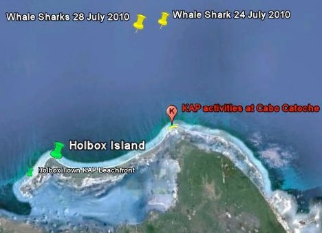
We used the methodology developed in previous years to do the KAP activities from a 27 foot outboard motor boat. We surveyed the northeastern side of the island and the whale shark observation area of the Yum- Balam Reserve north of Cabo Catoche.
RESULTS
Due to weather conditions we could only navigate three days of our stay in Holbox from July 23rd to July 28th, and we could undertake KAP activities on only two of those days. We used these windows of opportunity to conduct KAP surveys and verified that the oceanographical conditions, particularly the tides, have a very important influence on the wind patterns of this area.
We observed that during spring tides (which happen during full and new moon phases), the wind conditions were more stable and with higher intensity than during the neap tides (first quarter and third quarter moon phases). We correlated it with the occurrence of upwelling currents. We observed this correlation during last year’s summer expedition to Holbox, and in this trip we verified it again. We observed the relationship between the tides, the currents, and the wind patterns over the very shallow basin of the continental shelf that surrounds Holbox Island.
Spring tides are the tides with maximum amplitude during a moon cycle. They are the result of the combined maximum gravitational pull of the celestial bodies of the solar system over the oceans. Most of this pull comes from the gravity of the sun and the moon, the sun for being the largest celestial body in the solar system and the moon due its proximity to the earth.
This maximum gravity pull over the ocean basins also enhances vertical currents, such as the upwelling currents on certain areas of the continental shelf. In the case of Holbox, which is located on the western margin of the channel of Yucatán, the upwelling currents occur where the waters of the Caribbean meet the waters of the Gulf of Mexico. Upwelling currents bring waters from the bottom, which are rich in nutrients and cold in temperature, to the surface. During a spring tide, these colder waters penetrate farther in over the internal continental shelf, creating areas of different barometric pressure and therefore creating local wind. The effect of the local wind over the horizontal ocean currents helps to push the surface waters to shallower areas, and it allows the upwelling current to last longer. This is what apparently happens during spring tides in the basin of the Yum Balam Reserve, Quintana Roo, Mexico. To prove this correlation, it is necessary to analyze the meteorological records of this area quantitatively.
It was evident that the strongest and more stable winds always occurred in the adjacent waters and at a distance of 2 to 3 miles around the island. The weaker wind patterns occurred in the offshore waters. This is explained by the higher contrast in barometric pressure and temperature between the landmass of the island and the ocean waters that surround it.
The wind conditions in the offshore waters, where we found whale sharks feeding on the surface, were low and not strong enough to elevate any of the cameras with the kites we had. This was quite disappointing, but we could not extend our stay on the island long enough to wait for the right wind conditions in order to document the whale sharks. These low wind conditions found in offshore waters are associated with the warming of the water over the shallow continental shelf which creates low atmospheric pressure conditions.
However, in the near shore waters of Holbox Island, strong enough wind conditions were found to elevate the Nikon D90 camera. So we decided to document with KAP the coastline of the northeastern side of the island, where a strong erosion process has been observed in the last 10 years.
We did two flights in this area in order to observe the bottom conditions and the sedimentary transport: one over a transect perpendicular to the coastline and a second over a transect parallel to the coastline (shown below as yellow and blue trails).
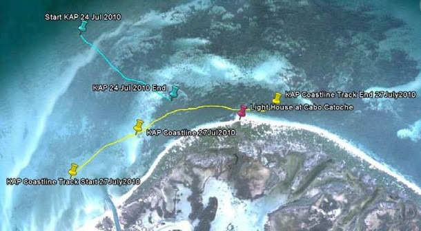
This side of Holbox Island is a very shallow area with depths up to 9 feet. The lighthouse of Cabo Catoche is located here and provides a great landmark to compare the photos obtained in this trip with images taken in the past by other researchers. The bathymetry in this area is very uniform and shallow. The limestone sandy bottom is covered with sea grass, algae, and a coral community distributed in patches.
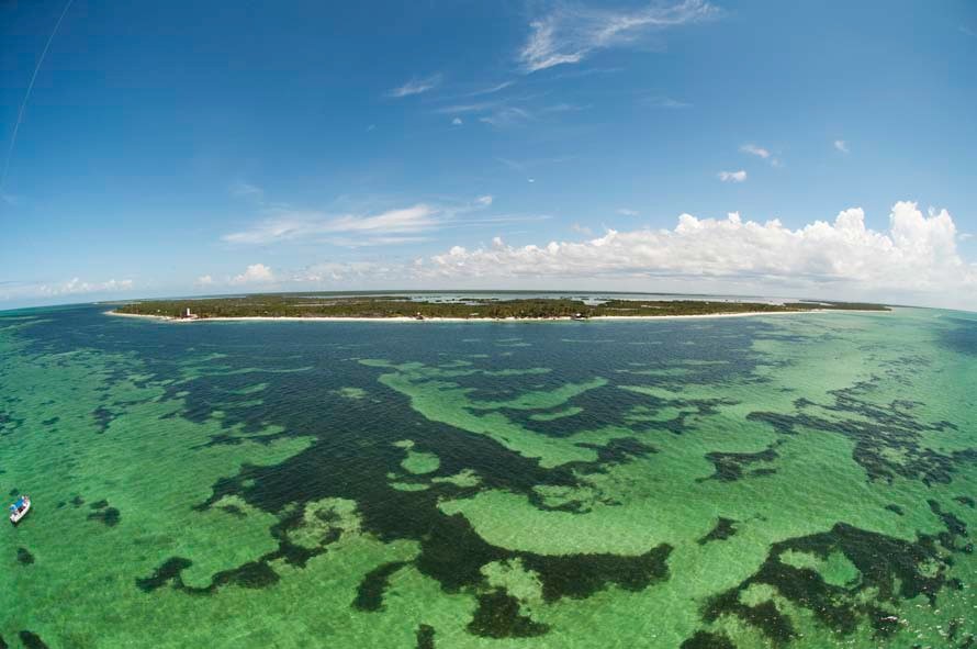
Broad view of the strip of land that conforms Cabo Catoche.
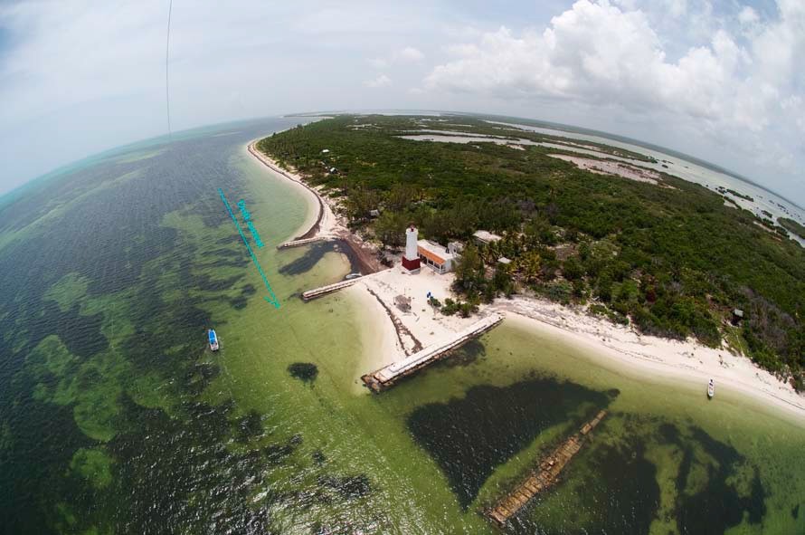
Erosion evidence at Cabo Catoche and striated bottom patterns on the shallower areas.
We found that on the northeastern side of Holbox Island the prevailing drift current flows parallel to the coastline from north to south. A huge portion of the shoreline has been eroded. This can be quantified by comparing the photos obtained at Cabo Catoche in this survey with detailed images from the past posted on Google Earth and other publications.
We noted the presence of striated disturbance patterns with parallel orientation on the very shallow areas around Cabo Catoche that have daily navigation traffic. This is evidence that bottom conditions are affected by boat traffic in the shallower areas, creating disturbances over the sediment deposition and the sea grass and algae distribution over the bottom.
The results obtained in this survey prove that KAP is a valuable technique to document and evaluate coastal dynamic processes and expands its potential applications to scientific research as a noninvasive exploration technique of marine coastal environments.
It is very important to be aware that we need to understand the relationships between ocean processes and wind patterns over coastal areas in order to use this technique further in the study and conservation of marine environments and their natural resources.
ACKNOWLEDGEMENTS
I am very grateful to the National Institute of Anthropology and History. Special thanks to Diana Trejo, Director of the National Park of Dzibilchaltun, Yucatán, México and to the archeologist Rubén Maldonado for providing the permits and authorizations to practice KAP at Dzibilchaltun repeatedly since November 2006 and for closing the park for such purposes.
A special acknowledgement to Dr. Jorge Euán, researcher, professor, and correspondent of the Laboratory of Remote Sensing and Geographical Information Systems of the Marine Resources Research Center in Mérida, Yucatán, for his interest and support of the application of KAP on different lines of research in the Yucatán Peninsula since November 2006.
My most deep acknowledgement and appreciation to Alfonso Cuevas for his friendship, professional assistance, hospitality, and for sharing the warmth of his home and family.
Thanks to Andrés Maldonado and Jennifer Saurí for their friendship, patience, and support during long and repeated field trips to Dzibilchaltun since 2006 and for assisting me in the laboratory of image processing.
A very special acknowledgment to Ruben Raygosa and Mario Bustamante for sharing their expertise and for providing technical assistance repairing my rigs and other electronic equipment during my field trips in the Yucatán Peninsula.
Thanks to Juan Ávila for his help with the boat operations and logistics at Holbox, for his patience during long hours of navigation, and for the humorous spicy Caribbean ceviche moments.
Thanks to Jorge Guzmán and Sigifredo Velázquez for their unconditional support, their patience, and humorous assistance during the long hot and humid days at Holbox.
A very personal acknowledgement to Leland Sutton for his friendship and patience during the long hot hours of navigation during the field trip to Holbox and for teaching me the importance of constant learning and endurance in life.
Thanks to Carmelo and Onny for their hospitality at Holbox and a special acknowledgement to Alejandra del Castillo and Luca Niero for their friendship, support, sincerity, and the perfume of their Mediterranean cuisine.
A very personal acknowledgement to Keith May from Deep Blue Conservancy for his friendship, advice, and constant dedication and support to the development of KAP and its applications for the exploration and conservation of marine environments.
My deepest appreciation and gratitude to the Drachen Foundation for opening their hearts and introducing me to KAP. I am especially grateful to Alison Fujino and Scott Skinner for believing in me, for their assistance, prudent advice, and personal dedication to help me develop the KAP Whales Project in Mexico since August 2003.
A very special acknowledgement to Brooks Leffler and Peter Bults for their dedication in designing and building rigs customized for my SLR cameras and needs.
And last but not least important, I want to thank Mike Jones for designing and building customized Rokkaku kites that I have been using in the Yucatán Peninsula under extreme conditions during the last four years.